
Welcome to Guadalupe Mountains National Park
Welcome to the Guadalupe Mountains National Park Information Page.
Here you will find all you need to know about the natural history of the park.
Learn about the geology, trees, mammals, birds, or other plants and wildlife of the area.
Guadalupe Mountains National Park is located in Pine Springs, Texas, which is located 110 miles east of El Paso, Texas on U.S. Highway 62 / 180; 55 miles southwest of Carlsbad, New Mexico on U.S. Highway 62 / 180; 65 miles north of Van Horn, Texas on Texas Highway 54.
Getting There
The nearest major airport is El Paso, Texas at 115 miles west of the park. There are also airports at Carlsbad, New Mexico (50 miles from the park), and Midland-Odessa, Texas (170 miles).
No public transportation available.
Park Headquarters / Visitor Center
Park Headquarters Visitor Center at Pine Springs accessed via U.S. Highway 62 / 180 between Carlsbad, New Mexico and El Paso, Texas. Dog Canyon, on the park’s north side, is accessed via New Mexico State road 137.
From the North
1. Take Highway 285 South to Carlsbad, New Mexico and then take Highway 62 / 180 Southwest to the park.
2. Take I-25 South to El Paso, Texas then take Highway 62 / 180 East to the park.
From the East
1. Take I-40 West to Amarillo, Texas then take I-27 South to Lubbock, Texas then take Highway 62 West to Highway 62 / 180 West to the park.
2. Take I-10 or I-20 West to Highway 285 North to Carlsbad, New Mexico and then take Highway 62 /180 Southwest to the park.
From the South
1. Take I-10 or I-20 West to Highway 285 North to Carlsbad, New Mexico and then take Highway 62 /180 Southwest to the park.
From the West
1. Take I-40 East to Highway 285 South to Carlsbad, New Mexico then take Highway 62 / 180 Southwest to the park.
2. Take I-10 East to I-25 South to Highway 62 /180 East to the park.
Establishment the Guadalupe Mountains National Park
Guadalupe Mountains National Park was established on 30 Sep 1972. The park celebrated its 25th anniversary in 1997. It preserves the rugged spirit and remote wilderness of the American West. Here, in the ancient Guadalupe Mountains that tower so majestically into the Texas sky, a visitor can delight in grand views, diverse landscape, and small pleasures.
Wallace Pratt, a petroleum geologist who was charmed by the beauty and geology of the Guadalupe, purchased land in McKittrick Canyon in the 1930’s. In 1959, Pratt donated his land to the National Park Service. Additional land was purchased from J.C. Hunter, and in 1972, Guadalupe Mountains National Park was created by an act of congress.
Size of Guadalupe Mountains National Park
Acreage – as of September 23, 2000
Federal Land – 86,189.97
Non-Federal Land – 226.00
Gross Area Acres – 86,415.97
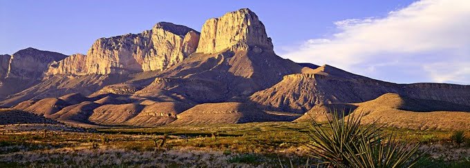
Geology of Guadalupe Mountains National Park
The rock exposures in Guadalupe Mountains National Park are part of one of the finest examples of an ancient fossil reef. It is largely because of the area’s geologic importance that it became a National Park in 1972. Geologists from around the world come to study this magnificent Permian-aged reef, which formed about 250 million years ago. The fossil reef was first described by geologist Dr. G.G. Shumard in 1855 while accompanying an expedition looking for artesian water. However, there was little interest in studying the area more intensely until petroleum was discovered in the Permian Basin in the 1920s.
Basic Visitor Recommendations
Bring everything you will need during your visit. No concessions or supplies available in the park; dress appropriately; be prepared for sudden weather changes; take adequate water into the backcountry (one gallon per person per day).
Bird Guide
Birding at Guadalupe Mountains National Park requires time, patience, luck, and hard work. Elevations in the park range from 3600 to 8749 feet and the park boundaries encompass several life zones each with its own variety of birdlife. Desert lowlands, pine forested mountain tops, deep canyons with their riparian woodlands, and the transition zones between all of these present a variety of habitats. Because of the park’s location in the mountains of west Texas, some species found nowhere else in the state occur here. Other species are more easily found here than in the rest of the state.
Hiking Guide
Hiking in Guadalupe Mountains National Park can be a fun and rewarding experience as in other national parks. It is a great way to both see and experience the park.
There are eighty-plus miles of trails, ranging in difficulty from easy to strenuous. Trails are rocky and often steep and rugged. Trails lead to Guadalupe Peak, around the base of El Capitan, up into the high country and across the top of the escarpment, and into McKittrick Canyon. Self-guided nature trails are located at McKittrick Canyon, Pinery trail at Pine Springs and Indian Meadow Trail at Dog Canyon.
The park’s color brochure includes a trail map of the backcountry. In addition to this guide, it is recommended that you carry a topographical map and a compass, and know how to use them. Some trails, especially those in the northwest corner of the park, are poorly-defined and can be difficult to follow. Give yourself enough time to reach your destination well before dark, and always have a flashlight and other light source in case of emergency.
Hiking Hints and Tips
- Sudden weather changes are common.
- High winds are prevalent in the spring.
- Thunderstorms and lightning are frequent in the summer.
- Avoid exposed open areas during storms.
- Hikers should carry one gallon of water per person per day.
- Stay on trails.
- Watch for cacti, rattlesnakes, scorpions, and desert centipedes.
- All park features are protected. Do not deface or remove any natural or historical objects.
- Do not pick wildflowers or other plants or feed or molest wildlife.
- Wood and charcoal fires are prohibited. Camp stoves are allowed.
- Pets must be leashed at all times. They are not allowed on trails.
- Carry a first aid kit with basic essentials and consider extras like tweezers for spines, moleskin for blisters, and a triangular bandage which can be put to many uses.
- Please, check in and out at trailhead registers and let park personnel know when you return. Share your interesting experiences, or difficulties encountered along the way.
- Protect your food from wildlife. Guadalupe Mountains National Park does have black bears, mule deer, skunks and others that may be interested in your goodies!
Backcountry Camping
A free permit is required for all overnight trips into the park. Permits are issued in person at the Visitor Center and Dog Canyon no more than 24 hours in advance.
Camping
There are two campgrounds; Pine Spring Campgrounds and Dog Canyon Campground. Both have water, restrooms and tables.
Fees and Permits
There is an entry fee at Guadalupe Mountains National Park (this was implemented in March 2003). The fee is a self registration fee payable at any of the trailheads in the park. The cost is $ 3.00 per person 16 and over and is good for 7 days. National Parks Pass and Golden Age Pass holders still enter free. There is no entry fee for visiting the visitor center or Frijole Ranch history museum.
Camping fees are paid by self registration at Pine Springs or Dog Canyon Campgrounds, ($8.00 a night per site, $4.00 with a golden age passport) and $ 25.00 minimum for group camping.
Food and Supplies
No gas, food, ice or supplies available in the park. Closest facilities are 35 miles northeast in White’s City, New Mexico. Water available at trailheads. There is no water in the park’s backcountry.
Weather of Guadalupe Mountains National Park
Spring
High winds are common during the months of February, March and often well into April, with wind gusts in excess of 100 mph. Strong wind advisories are often forecast by the National Weather Service for Guadalupe Pass. Hiking can be challenging on exposed trails. If temperatures are anything less than warm , the wind chill factor will force you to bundle up. During the spring months the average precipitation is less than an inch. Temperatures can be mild; the average high is 71 F, the low 46 F, with and all-time high of a simmering 92 F and an all-time low of -4 F.
Summer
Though May, June, and July are generally the hottest and the driest months, locally severe afternoon thunderstorms may bring a sudden drop in the temperature, and send you fleeing for shelter and a quick change from shorts and t-shirts to jackets and pants. Flash flooding can occur and caution should be used in arroyos and dry washes. It’s best to stay clear of open ridge tops during the lightning that frequently accompanies these storms. The average precipitation is 2.75 inches; temperatures range from high 80’s to low 60’s (averages). The all-time high and low respectively are 101 F and 40 F.
Fall
Fall is everyones favorite time to visit Guadalupe Mountains National Park, and for good reason! The weather is generally beautiful – mild, calm, and refreshed from the summer rains. Cool crisp days, and cold nights occur toward the latter days of October, and trigger the beautiful color change of the maples, sumacs, and oaks. The average rainfall is 2.43 inches. The average high is 70 F, the low 56 F, with an all-time high of 93 F and an all-time low of 1 F.
Winter
During the winter months (November – January) expect snowfall with cold temperatures and some mild days. Snow generally does not last more than a few days in the low country, but in the high country may linger much longer, especially on north face aspects, and may cause trails to be icy and muddy. Snow depths may be dramatically deeper at higher elevations. Average precipitation is .92 inches. Average high temperature is 56 F; low temperature is 33 F, with an all-time high of 78 F, and an all-time low of -6 F. The wind often blows quite strong with the passing of fronts.
Lightning
Spectacular scenery awaits you at Guadalupe Mountains National Park. But the hiking trails that take you to the beautiful vistas may also make you vulnerable to lightning. To better protect yourself from being struck, take the time to ask about locally predicted weather, carry adequate rain gear, and learn what to do if you are caught in a dangerous situation. Simple knowledge of lightning safety may save your life.